A reputable China tour operator & China travel agency from 1987

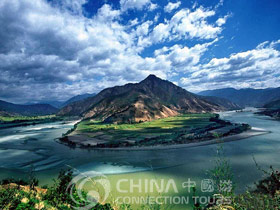
 The Yangtze River is the longest river in Asia and third longest in the world. The headwaters of the Yangtze are located at an elevation of about 16,000 feet above sea level in the Kunlun Mountains in the southwestern section of Qinghai. It flows generally south through Sichuan into Yunnan then northeast and east across central China through Sichuan, Hubei, Auhui, and Jiangsu Provinces to its mouth, 3,720 miles away in the East China Sea, north of Shanghai. The river has over 700 tributaries; the principal tributaries being the Hun, Yalong, Jialing, Min, Tuo Jiang, and Wu Jiang. The climate ranges from 96 F in the summer to cold, brisk temperatures in the winter. Precipitation is high due to the height of the mountains.
China covers an area of almost 3.7 million square miles and is the most populous country on earth having more than one billion people, about 400 million or about one-third of them live in the Yangtze Basin. Many are engaged in agriculture. The basin contributes nearly half of China's crop production, although only one-quarter of the basin is arable. There is plenty of wildlife along the river include Tibetan antelopes, Mongolian gazelles, and snow leopards, just to name a few. Waters of the Yangtze are often used for rice and wheat irrigation. It also has enormous and inexhaustible hydroelectric resources.
 The Yangtze has long functioned as a transportation artery, as a strategic boundary, and as the lifeline of a productive agricultural region. Although most of the river has been known for a long time, the Jinsha was first recognized as the headstream in the 16th century. In the 18th century, a Qing government expedition reached the Tibetan Plateau in search of the headwaters. The headwaters were only properly mapped in the 1970s and 1980s. The Three Gorges were charted by Captain Cornell Plant of the Chinese Imperial Maritime Customs Service in the early 20th century.
The river is intricately associated with benchmark events in Chinese history. Some of these include the warfare between the Three Kingdoms in the 3rd century, the Taiping Rebellion (1851-1864) that spread along the Grand Canal and the Yangtze, and the Japanese military advance and destruction along the river before and during World War II (1939-1945).
Economic development of the Yangtze Basin received a major boost from northern extensions of the Grand Canal between the 7th and 14th centuries. The canal provided an efficient means of transporting the agricultural products of the Yangtze Basin to northern China and, especially, the national capital, Beijing. In the 19th century, Shanghai and inland settlements developed as ports of trade with some connections to Western markets.
Numerous references to the Yangtze are found in Chinese mythology and literature. Many sites on the Yangtze are locations of incidents described in the well-known 14th-century novel Sanguozhi yanyi (The Romance of the Three Kingdoms). Chinese poets have written extensively about the beauty of the middle and lower Yangtze and the hazards of the gorges.
Late 1800's
 As a result of several so-called "unequal treaties" imposed on China by Great Britain after the Opium Wars, China was opened to foreign trade at a number of locations known as "treaty ports" where foreigners were permitted to live and conduct business. Also created by the treaties was the doctrine of extraterritoriality, a system whereby citizens of foreign countries living in China were subject to the laws of their home country, not those of China. Most favored nation treatment under the treaties assured other countries of the privileges afforded Great Britain, and soon many nations, including the United States, operated merchant ships and navy gunboats on the waterways of China. During the 1860's and 1870's American merchant ships were prominent on the lower Yangtze, operating up to the deep water port of Hankou 300 miles inland.
1900's
In 1901 American-flag merchant vessels returned to the Yangtze when Standard Oil Company placed a steam tanker in service on the lower river. At the same time the Navy acquired several ex-Spanish gunboats, which were seized in the Philippines during the Spanish-American War. These vessels became the core of the Yangtze River patrol for the first dozen years of the twentieth century, but they lacked the power to go beyond Yichang onto the more difficult stretches of the river. In 1913 the first American gunboats were built specifically for service on the Yangtze River. In 1917 the first Standard Oil tanker reached Chongqing, and a pattern of American commerce on the river began to emerge. These vessels gave the navy the capability it needed at a time when operational requirements were growing rapidly. Naval reaction to hostilities along the river peaked in the early 1920's and 1930's.
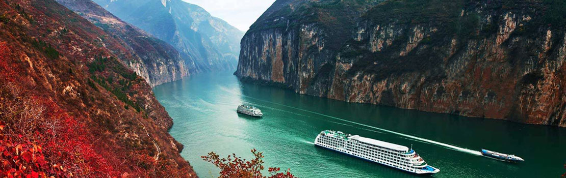
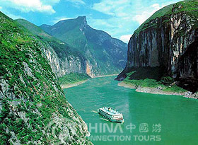
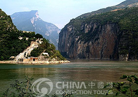
The Yangtze flows through nine provinces and forms the eastern border of the Tibet Autonomous Region (TAR). The course of the Yangtze is traditionally divided into three sections. The mountainous Upper Yangtze is the course from the headwaters in western Qinghai Province to the city of Yichang in Hubei Province. The Middle Yangtze flows through a flat plain from Yichang to Hukou in Jiangxi Province. The Lower Yangtze stretches from Hukou to the East China Sea. In the upper section, the Yangtze flows through deep gorges, becoming turbulent and dangerous. Beyond Chongqing, the Yangtze flows northeast through a mountainous area up to Wan Xian, where it turns east to drop steeply through three gorges. The first and the narrowest gorge, Qutang Xia, is 8 km (5 mi) long. The middle gorge, Wu Xia, is 40 km (25 mi) long and bounded by high cliffs. The last gorge, Xiling Xia, is the longest at 75 km (46 mi). The gorges, known collectively as San Xia (Three Gorges), are considered one of the most scenic stretches of the river.
 Since the 1920's, when the dam was first proposed, the Three Gorges Dam has been a topic for debate in the People's Republic of China. In December of 1995, Chinese Premier Li Peng officially launched the project at a construction site at Sandouping. The Yangtze has immense economic importance in China. It provides irrigation water for agriculture, a source of hydroelectric power, a waterway for cargo vessels, scenic points of interest for tourism, and a great transportation network through the heart of some of the most densely populated and economically important areas in China. Some of China's most important industrial centers are located on the Yangtze, including Wuhan and Chongqing.
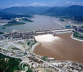
In 1994 construction began on the Three Gorges Dam, which will rank as the world's largest hydroelectric dam when it is completed in 2009. Both floods and droughts are common in the basin. Floods generally occur every two or three years. In addition to large floods, the Yangtze suffers a number of environmental problems, including slope erosion, sedimentation, and industrial and organic pollution from large cities. Today the Yangtze continues to be an extremely important inland waterway for commerce and industry. Oceangoing vessels can reach as far inland as Wuhan, and large cargo and passenger boats can reach Chongqing. Small boats travel farther upriver to Xinshezhen, about 3,000 km (about 1,860 mi) from the sea. However, the development of railways has reduced transportation along the Yangtze. Before 1949 railroads running north and south were interrupted by the river. Goods and passengers had to cross by ferry. Several railroad bridges have been built since then. A number of dams and canal networks meet the high regional demand for irrigation and electricity. ?Thousands of dams are located in the Yangtze Basin, but only two of them-the Three Gorges Dam and Gezhou Dam-are on the Yangtze itself.
The Three Gorges Dam is at Sanduping, near Yichang. When completed, the dam will measure more than 200 m (600 ft) high and 1.6 km (1 mi) long, making it the largest in the world. The dam is designed to generate about 18,000 megawatts of electricity-more than any other hydroelectric facility in the world that will be distributed throughout central China. The dam is also designed to control flooding and improve navigation upriver. The dam will create a reservoir 650 km (400 mi) long, from Yichang, through the Three Gorges, and to Chongqing. The government of the People's Republic of China has characterized the Three Gorges Dam as a source of national pride and a necessary project to provide the growing population of the region with electricity, irrigation water, and flood control. One third of China's 1.2 billion people live in the Yangtze River valley, and it is estimated that between 1.5 and 2 million of them will have to relocate as dam waters rise.
A hydroelectric dam harnesses water to create electricity. The Three Gorges Dam is expected to create as much electricity as 18 nuclear power plants about 18.2 million kilowatts per year. That's up to 1/9 of the electricity currently used per year by this country of approximately 1.4 billion people.