A reputable China tour operator & China travel agency from 1987

China is a vast country, located in the eastern part of the Asian continent, on the western Pacific Rim. It is the world's fourth largest country covering an area of 9.6 million square kilometers. With additional offshore territory, including territorial waters, special economic areas, and the continental shelf, China's overall territory covers almost 13 million square kilometers.

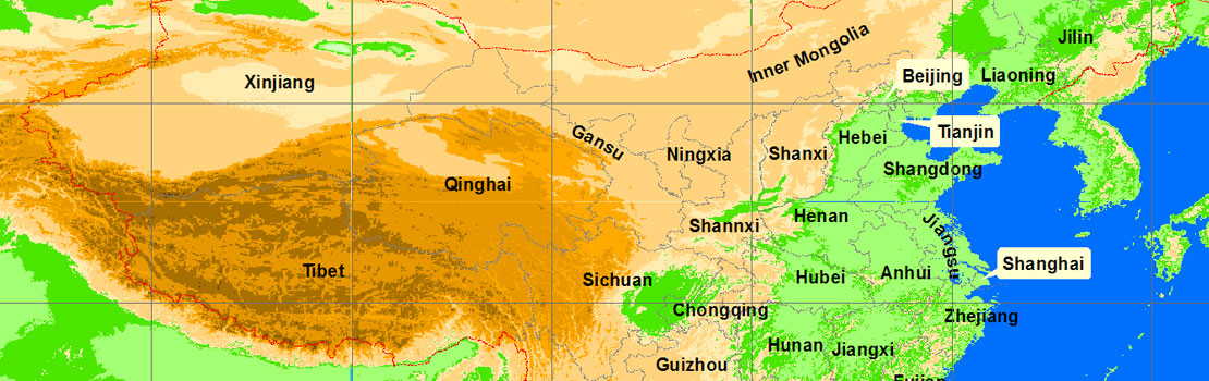
China topography varies greatly from highly mountainous regions to inhospitable desert zones and flat, fertile plains. It can be compared to a staircase descending from west to east. The Tibetan Plateau forms the highest part of the country (the first step). Known as the 'roof of the world', the Tibetan-Qinghai Plateau is more than 5,000 feet above sea level. The Himalayan mountain range has a number of peaks over 23,000 feet, with the tallest in the world, Mount Everest, at the Sino-Nepalese border, Melting snows from these peaks are the source of several of the main Chinese rivers including the Yangtze and the Yellow River which run from west to east.
The second step is the Inner Mongolia and Yunnan-Guizhou Plateau as well as the Tarim, Sichuan and Junggar basins. The Tarim Basin is the site of Xinjiang Autonomous Region where the largest desert in China, the Taklimakan, is located. The plains of the Yangtze River and of northern and eastern China are the country’s most populated areas and the agricultural center of the country.
Finally the coastal zones, stretching from Vietnam to North Korea and bordering the South China, East China and Yellow Seas, join the Pacific Ocean.